Portal:Pittsburgh
The Pennsylvania Portal Pennsylvania (/ˌpɛnsɪlˈveɪniə/ ⓘ PEN-sil-VAY-nee-ə; Pennsylvania German: Pennsilfaani), officially the Commonwealth of Pennsylvania, is a state spanning the Mid-Atlantic, Northeastern, Appalachian, and Great Lakes regions of the United States. Pennsylvania borders Delaware to its southeast, Maryland to its south, West Virginia to its southwest, Ohio to its west, Lake Erie and the Canadian province of Ontario to its northwest, New York to its north, and the Delaware River and New Jersey to its east. Pennsylvania is the fifth-most populous state in the United States, with over 13 million residents as of the 2020 United States census. The state is the 33rd-largest by area and has the ninth-highest population density among all states. The largest metropolitan statistical area (MSA) is the southeastern Delaware Valley, which includes and surrounds Philadelphia, the state's largest and nation's sixth-most populous city. The second-largest metropolitan area, Greater Pittsburgh, is centered in and around Pittsburgh, the state's second-largest city. The state's subsequent five most populous cities are Allentown, Reading, Erie, Scranton, and Bethlehem. The state capital is Harrisburg. Pennsylvania's geography is highly diverse. The Appalachian Mountains run through the center of the state; the Allegheny and Pocono mountains span much of Northeastern Pennsylvania; close to 60% of the state is forested. While it has only 140 miles (225 km) of waterfront along Lake Erie and the Delaware River, Pennsylvania has the most navigable rivers of any state in the nation, including the Allegheny, Delaware, Genesee, Ohio, Schuylkill, Susquehanna, and others. (Full article...)
|


| Pennsylvania | Philadelphia | Pittsburgh |
| Erie | Lehigh Valley | Pennsylvania Roads |
 Good article -
The Appalachian Trail, also called the A.T., is a hiking trail in the Eastern United States, extending almost 2,200 miles (3,540 km) between Springer Mountain in Georgia and Mount Katahdin in Maine, and passing through 14 states. The Appalachian Trail Conservancy claims the Appalachian Trail to be the longest hiking-only trail in the world. More than three million people hike segments of the trail each year.
The trail was first proposed in 1921 and completed in 1937. Improvements and changes have continued since then. It became the Appalachian National Scenic Trail under the National Trails System Act of 1968. (Full article...)Selected article -

The Mason–Dixon line, also called the Mason and Dixon line or Mason's and Dixon's line, is a demarcation line separating four U.S. states, forming part of the borders of Pennsylvania, Maryland, Delaware, and West Virginia (part of Virginia until 1863). It was surveyed between 1763 and 1767 by Charles Mason and Jeremiah Dixon as part of the resolution of a border dispute involving Maryland, Pennsylvania, and Delaware in the colonial United States. The dispute had its origins almost a century earlier in the somewhat confusing proprietary grants by King Charles I to Lord Baltimore (Maryland), and by his son King Charles II to William Penn (Pennsylvania and Delaware).
The largest portion of the Mason–Dixon line, along the southern Pennsylvania border, later became informally known as the boundary between the Southern slave states and Northern free states. This usage came to prominence during the debate around the Missouri Compromise of 1820, when drawing boundaries between slave and free territory was an issue, and resurfaced during the American Civil War, with border states also coming into play. The Confederate States of America claimed the Virginia portion of the line as part of its northern border, although it never exercised meaningful control that far north – especially after West Virginia separated from Virginia and joined the Union as a separate state in 1863. It is still used today in the figurative sense of a line that separates the Northeast and South culturally, politically, and socially (see Dixie). (Full article...)Pennsylvania news
- November 2: On the campaign trail in the USA, October 2020
- October 29: On the campaign trail in the USA, September 2020
- September 30: On the campaign trail in the USA, August 2020
- August 31: On the campaign trail in the USA, July 2020
- November 21: Slippery business: Materials scientists invent new coating for self-cleaning, water-efficient toilets
Categories

State facts
State Facts

- Nickname: The Keystone State
- Capital: Harrisburg
- Largest city: Philadelphia
- Total area: 119,283 square kilometers (46,055 square miles)
- Population (2000 census): 12,281,054
- Date admitted to the Union: December 12, 1787 (2nd)
State symbols

- Bird: Ruffed grouse
- Fish: Brook trout
- Floral emblem: Mistletoe
- Flower: Mountain laurel
- Insect: Pennsylvania firefly
- Mammal: White-tailed deer
- Tree: Eastern Hemlock
- Fossil: Trilobite
- Soil: Hazleton
- Song: Pennsylvania
Pennsylvania topics

General images
-
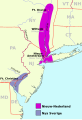
A map of New Netherland (in magenta) and New Sweden (in blue) in the 17th century; New Sweden was later absorbed by New Netherland and then the British in the Second Anglo-Dutch War. (from History of Pennsylvania)
-

One of only two confirmed photos of Abraham Lincoln (sitting in center, facing camera, without his traditional top hat) at Gettysburg a few hours prior to giving the Gettysburg Address at Gettysburg National Cemetery on November 19, 1863. The address, which was only 271 words in length, ranks among the most famed speeches in American history. (from History of Pennsylvania)
-

The Battle of Gettysburg, fought July 1–3, 1863 in Gettysburg, was the Civil War's deadliest battle but also is widely considered the war's turning point in the Union's ultimate victory. The battle is depicted in this 1887 Thure de Thulstrup painting, Battle of Gettysburg. (from Pennsylvania)
-
South Philadelphia High School on Broad Street in South Philadelphia in February 2010 (from Pennsylvania)
-

The Gettysburg campaign, which culminated in the Battle of Gettysburg, was a major turning point in the American Civil War and the war's bloodiest battle with an estimated 46,000 to 51,000 casualties (from History of Pennsylvania)
-

The colonial possessions of Britain (in pink), France (in blue), and Spain (in orange) as of 1750. The French later lost their possessions in North America to Britain following its defeat in the French and Indian War, fought from 1754 to 1763 (from History of Pennsylvania)
-

Frederick Winslow Taylor of Philadelphia, a late 19th and early 20th century pioneer in scientific management (from History of Pennsylvania)
-

The Hershey Company in Hershey (from Pennsylvania)
-
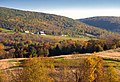
Autumn in North Branch Township in Wyoming County, October 2011 (from Pennsylvania)
-

Benjamin Franklin, a Founding Father of the United States and Pennsylvania delegate to the Second Continental Congress, which created the Continental Army in 1775 and unanimously adopted and issued the Declaration of Independence on July 4, 1776 (from History of Pennsylvania)
-

Simon Cameron of Maytown was Secretary of War and head of Pennsylvania's Republican Party, whose party machine controlled Pennsylvania into the 20th century. (from History of Pennsylvania)
-
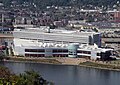
Rivers Casino, located on the Ohio River in Pittsburgh, one of Pennsylvania's 16 casinos (from Pennsylvania)
-

William Penn, a Quaker and son of a prominent admiral, founded the colonial Province of Pennsylvania in 1681. (from Pennsylvania)
-

Shelter House in Emmaus, constructed in 1734 by Pennsylvania German settlers, is the oldest continuously occupied building structure in the Lehigh Valley and one of the oldest in Pennsylvania (from Pennsylvania)
-

Philadelphia International Airport, the busiest airport in the state and the 21st-busiest airport in the nation with nearly 10 million passengers annually as of 2021 (from Pennsylvania)
-
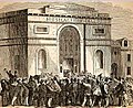
A woodcut illustration of the crowd at the first Republican National Convention in 1856 at Musical Fund Hall at 808 Locust Street in Philadelphia (from History of Pennsylvania)
-

Stephen Decatur, a 19th-century naval commander who served in the War of 1812 and other engagements (from History of Pennsylvania)
-
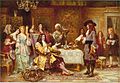
The Birth of Pennsylania, a portrait of William Penn (standing with document in hand), who founded the Province of Pennsylvania in 1681 as a refuge for Quakers after receiving a royal deed to it from King Charles II (from History of Pennsylvania)
-

-

Citizens Bank Park in South Philadelphia, home of the Philadelphia Phillies, the oldest continuous same-name, same-city franchise in American professional sports (from Pennsylvania)
-

The Pennsylvania State Capitol in Harrisburg (from Pennsylvania)
-
On November 19, 1863, President Abraham Lincoln (center, facing camera) arrived in Gettysburg and delivered the Gettysburg Address, considered one of the best-known speeches in American history. (from Pennsylvania)
-
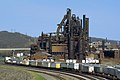
Bethlehem Steel in Bethlehem was one of the world's leading steel manufacturers for most of the 19th and 20th century. In 1982, however, it discontinued most of its operations, declared bankruptcy in 2001, and was dissolved in 2003. (from Pennsylvania)
-
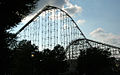
Dorney Park & Wildwater Kingdom's Steel Force and Thunderhawk roller coasters in Allentown; Steel Force is the eighth-longest steel roller coaster in the world with a first drop of 205 feet (62 m) and a top speed of 75 miles per hour (121 km/h). (from Pennsylvania)
-
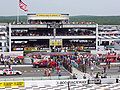
NASCAR racing at Pocono Raceway in Long Pond (from Pennsylvania)
-

The Stonycreek Township crash site of Flight 93, one of four planes hijacked in the September 11 attacks; the site is now a national memorial. Flight 93 passengers wrestled with al-Qaeda terrorist hijackers for control of the plane, preventing it from being flown into the White House or U.S. Capitol. (from Pennsylvania)
-

The locomotive Tioga in Philadelphia in 1848; Pennsylvania was an important railroad center throughout the 19th century. (from History of Pennsylvania)
-
 2020 U.S. presidential election results by county in PennsylvaniaDemocraticRepublican(from Pennsylvania)
 -
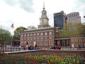
Independence Hall in Philadelphia, where the Declaration of Independence and United States Constitution were adopted in 1776 and 1787-88, respectively (from Pennsylvania)
-

-
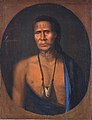
Lenape chief Lappawinsoe, depicted in a 1735 painting by Gustavus Hesselius (from History of Pennsylvania)
-

An Amish family riding in a traditional Amish buggy in Lancaster County; Pennsylvania has the largest Amish population of any state. (from Pennsylvania)
-

The Philadelphia Eagles are presented with the Vince Lombardi Trophy after winning Super Bowl LII on February 4, 2018 (from Pennsylvania)
-
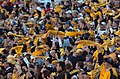
Pittsburgh Steelers' fans waving the Terrible Towel, a tradition that dates back to 1975 (from Pennsylvania)
-

Köppen climate types in Pennsylvania (from Pennsylvania)
-
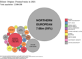
Ethnic origins of Pennsylvanians (from Pennsylvania)
-

The statue of Benjamin Franklin on the campus of the University of Pennsylvania, an Ivy League institution in Philadelphia ranked one of world's top universities (from Pennsylvania)
-

Amtrak's Pennsylvanian on Horseshoe Curve in Logan Township (from Pennsylvania)
-

Pat's King of Steaks in South Philadelphia is widely credited with inventing the cheesesteak in 1933 (from Pennsylvania)


.jpg)


.jpg)


.jpg)


.jpg)

Associated Wikimedia
The following Wikimedia Foundation sister projects provide more on this subject:
-
 Commons
Free media repository -
 Wikibooks
Free textbooks and manuals -
 Wikidata
Free knowledge base -
 Wikinews
Free-content news -
 Wikiquote
Collection of quotations -
 Wikisource
Free-content library -
 Wikiversity
Free learning tools -
 Wikivoyage
Free travel guide -
 Wiktionary
Dictionary and thesaurus
-
List of all portals List of all portals -

The arts portal -

Biography portal -

Current events portal -

Geography portal -

History portal -

Mathematics portal -

Science portal -

Society portal -

Technology portal -

Random portal -
WikiProject Portals WikiProject Portals
This page was last updated at 2023-11-03 04:43 UTC. Update now. View original page.
All our content comes from Wikipedia and under the Creative Commons Attribution-ShareAlike License.